SignIn
Kerala Kaumudi Online
Sunday, 08 December 2024 5.18 PM IST

Know about pollution on route to your destination; Google Maps to provide Air Quality Index

Increase Font Size Decrease Font Size Print Page
google-maps

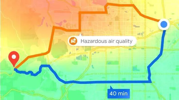
Google Maps which provides real-time GPS navigation, traffic, etc., will provide information of the level of air pollution at the destination from now on. There will also be an explanation of how air quality affects health. The feature is in an updated version of Google Maps. The service will be available on Both Android and iPhones. It can be downloaded from the Play Store.

Globally, this feature is available in 40+ countries, including India. If air pollution is high in the area, Google Maps will warn or suggest a less polluted route.

Google Maps collects basic information from the central and state pollution control boards. The index will vary depending on the wind speed, direction and topography. Normal Air quality indicators are updated within 24 hours. The one on Google Maps will be updated every hour.

Different color, number

  • Turn on Google Maps and type in where to go. The color on the map changes depending on the level of air pollution in the area
  • The green colour indicates safe air. Yellow is air of moderate quality. If it's red, it's highly polluted. It is worse if it's purple

Numbers from zero to 500 will also be shown on the map.

  • 0–50: Good
  • 51–100: Satisfactory
  • 101–200: Moderate
  • 201–300: Poor
  • 301–400: Very Poor
  • 401–450: Severe
  • above 450: Severe Plus
TAGS: POLLUTION, GOOGLE, MAP
JOIN THE DISCUSSION
KERALA KAUMUDI EPAPER
TRENDING IN LIFESTYLE
X
Lorem ipsum dolor sit amet
consectetur adipiscing elit, sed do eiusmod tempor incididunt ut labore et dolore magna aliqua. Ut enim ad minim veniam, quis nostrud exercitation ullamco laboris nisi ut aliquip ex ea commodo consequat.
We respect your privacy. Your information is safe and will never be shared.