

KATHMANDU: Nepal was struck by a devastating flash flood on Wednesday morning after an ice-and-rock avalanche near the Nepal-China border blocked a river and sent a powerful surge of water and debris downstream. The disaster struck suddenly, leaving little time for people to understand what was happening. Rivers turned into raging torrents, sweeping through villages and damaging roads, bridges and other infrastructure. Communication links were also disrupted in several affected areas.
The flooding occurred without significant rainfall at the immediate site. Experts and satellite imagery indicated that the disaster was triggered by the collapse of a section of glacier, sending ice and rock into the Lhende Khola and temporarily obstructing its flow.
8.37 a.m.: A powerful seismic signal was recorded near the Nepal-Tibet border, about 55 km northwest of Kodari village. It was initially reported as an earthquake. The US Geological Survey later determined that the signal was associated with the collapse of glacial ice and rock and the resulting debris flow.
The ice-and-rock avalanche crashed into the narrow valley and blocked the Lhende Khola. The obstruction temporarily held back water before giving way, releasing a sudden surge of water, mud, rocks and debris downstream.
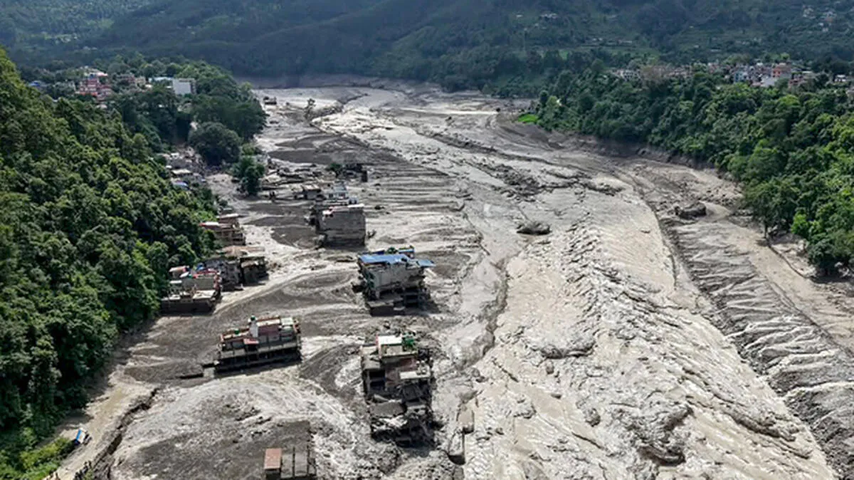
Around 9 a.m.: The surge reached the Bhote Koshi river system with tremendous force. Mud, rocks, ice and other debris were swept downstream, inundating settlements and damaging roads, bridges and hydropower infrastructure.
The flood also reached the Gyirong border crossing area on the Tibetan side, where buildings and vehicles were inundated or swept away.
Later in the morning: The flash flood continued downstream through areas of Rasuwa and Nuwakot. Villages were inundated, bridges and roads were damaged or destroyed, and hydropower projects were severely affected. Landslides were also reported in the affected areas.
Around 19 bridges were damaged or destroyed, according to initial assessments, while several hydropower facilities suffered major damage.
The scale of the destruction became clearer as rescue teams reached the affected areas. The Nepal Army and police were deployed for search-and-rescue operations, while helicopters were used to survey affected areas and evacuate stranded people.
Aerial views showed large stretches of the affected valleys covered in mud and debris. Settlements were destroyed, while roads and bridges were washed away, making rescue and relief operations difficult.
The flood travelled downstream through the Bhote Koshi and Trishuli river systems, leaving extensive destruction along the river corridors.
The river levels rose rapidly, adding to the destructive force of the flood. In one monitoring location, the Trishuli River rose by about nine metres within 30 minutes.
Rescue operations continued as authorities searched for people affected by the disaster and assessed the extent of the damage.













 HOME
HOME LATEST
 NOTIFIED NEWS
 POLL
POLL KERALA
  EDITORIAL
  INDIA
INDIA  WORLD
WORLD  BUSINESS
  CINEMA
  SPORTS
  LIFESTYLE
  SPECIAL
  SCIENCE & TECHNOLOGY
 |
|